Weather Watch: Next storm system expected Monday
Published 12:05 pm Sunday, January 7, 2024
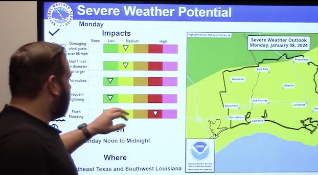
The risk of severe weather continues to increase across the region Monday with the area facing two days of strong, damaging winds.
Meteorologist Donald Jones with the National Weather Service’s Lake Charles office said he’s expecting strong winds to develop both ahead and behind a cold front that will move through the area Monday evening.
“If you’re enjoying the very nice weather out there this morning — it’s cool, it’s clear, it’s sunny and very January-like for this part of the area — I’ve got some bad news for you,” he said. “Unfortunately it’s not going to last too much longer. We’ve got a storm system that’s going to be moving to the area tomorrow and coming with it will be the threat for severe weather.”
Trending
Jones said a strong low pressure is expected to develop over Texas this afternoon with showers and storms becoming more widespread as it makes its way across Southwest Louisiana throughout the day Monday.
He said the expected timeframe for severe weather is about noon to midnight on Monday.
Flash flooding could become a problem with this system, Jones said, because of the recent rainfall the area has experienced over the last few days. Monday’s storm could bring 1-4 inches.
The area could also experience 30-40 mph wind with wind gusts up to 50 mph outside of the storms that have the potential of creating localized power outages.
There’s also a 15-20 percent chance the area will be inundated with large hail.
Trending


-
eEdition
-
-
