Caribbean system expected to strengthen, could hit Florida as a major hurricane
Published 12:06 pm Monday, September 23, 2024
There are no expected direct tropical impacts forecast for the Southwest Louisiana area this week from a tropical disturbance developing in the Caribbean Sea.
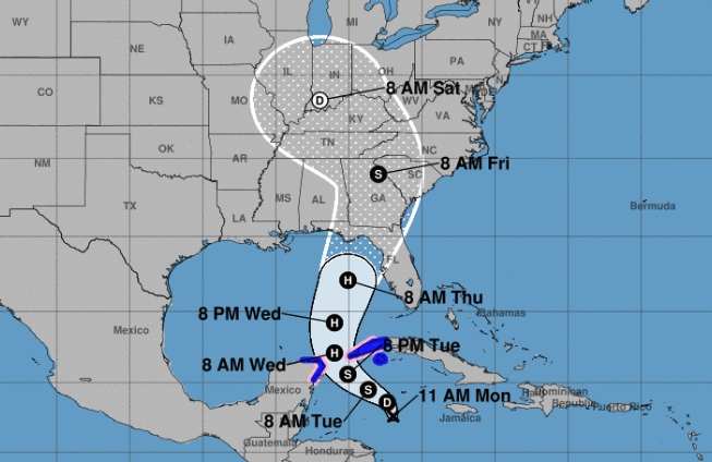
The National Hurricane Center is reporting a broad area of low pressure over the northwestern Caribbean Sea that has a 80 percent chance of tropical development over the next two days.
Labeled potential Tropical Cyclone Nine, the storm could approach Florida as a hurricane later this week.
“Everyone along the Florida Panhandle and Big Bend region needs to be prepared for hurricane impacts,” said AccuWeather Lead Hurricane Expert Alex DaSilva. “This setup has the potential to become the strongest hurricane landfall in the U.S. so far this season.”
This developing tropical threat is currently forecast to impact similar areas that were hit hard by Hurricane Idalia in August 2023.
When it develops, the storm will be named Helene, the eighth named storm of the 2024 hurricane season that ends Nov. 30.
AccuWeather meteorologists are forecasting a widespread 4-8 inches of rainfall across the Florida Panhandle and Big Bend Region through Saturday, with a zone of 8-12 inches of rain possible near the landfall zone.
In the meantime in Southwest Louisiana, a series of cold fronts are expected to pass through the region Tuesday and Wednesday, according to the National Weather Service’s Lake Charles office.
“The area will receive scattered showers and storms, however, these features are separate from the developing tropical disturbance and are forecast to keep the favorable development region over the eastern Gulf of Mexico,” the agency said.
Wednesday’s temperatures are expected in the mid- to-late 80s, while Thursday’s temperatures are predicted in the low- to mid-80s. Temperatures are expected to drop into the low 60s both nights.


