Texas officials urge coastal residents to prepare as Beryl heads their way
Published 1:52 pm Friday, July 5, 2024
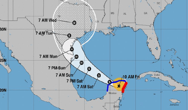
The forecast track for Hurricane Beryl has shifted northward, and chances favor the storm to make landfall along the south Texas coastline.
Beryl hit Mexico as a Friday Category 2 hurricane but weakened to a tropical storm as it moved across the Yucatan Peninsula. National Weather Service Lake Charles Storm Warning Coordinator Doug Cramer said Beryl is expected to regain hurricane strength once it emerges into the Gulf of Mexico.
“Additional weakening is expected as it moves over the Yucatan Peninsula,” Cramer said. “Some strengthening is expected as it re-emerges over the southern Gulf of Mexico tonight.”
Some counties in Texas have issued voluntary evacuation orders in low-lying areas.
“Impacts across southern Louisiana are still expected to be limited to minor coastal flooding rip currents; however, expected rainfall amounts may increase,” Cramer said.
As Southwest Louisiana continues to monitor Beryl, a weak boundary is expected to stall over the area Saturday, providing a focus for more widespread thunderstorms than have been seen the last couple of days, said NWS-Lake Charles meteorologist Donald Jones.
“The very tropical airmass in place across the region will allow these storms to produce periods of heavy rainfall that could lead to nuisance flooding,” Jones said. “The increased cloud cover and storms are expected to keep heat indices below heat advisory criteria.”
Jones said there is a risk of flash flooding Tuesday-Thursday as the remnants of Beryl move into Eastern Texas, but the overall flood risk “will be highly dependent on the eventual track of the remnants and confidence in the potential for flash flooding is low at this time.”