UPDATE: ‘Widespread mess’ of showers, thunderstorms here
Published 1:31 pm Monday, January 8, 2024
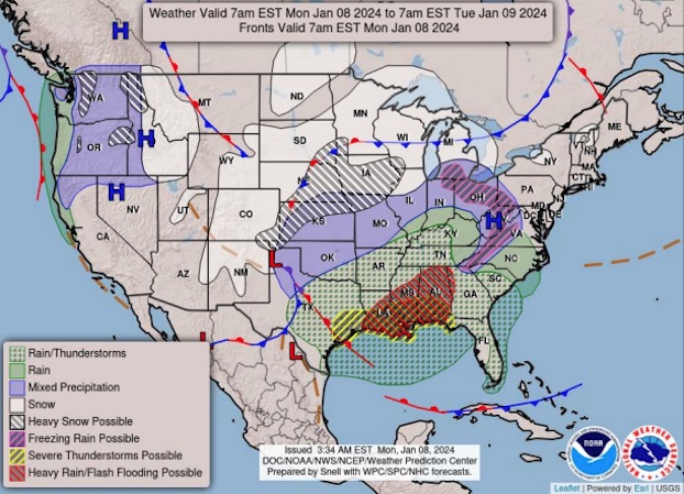
Severe weather is predicted to roll through Southwest Louisiana and Southeast Texas through midnight.
Meteorologist Donald Jones with the National Weather Service’s Lake Charles office said the conditions — especially strong winds — are caused by a strong area of low pressure that developed in North Texas and is moving through the southern plains today.
He called the pockets of precipitation a “widespread mess of showers and thunderstorms” with the potential to bring severe conditions. It cannot be determined with certainty which storms moving through will become strong or severe.
Trending
“It’s impossible to predict exactly which areas are going to see that tornado, severe thunderstorm or hail before it actually occurs.”
The southern coast is predicted to receive the brunt of the severe weather conditions — tornadoes, damaging winds, large hail — and is classified as an enhanced risk area. Jones said this is unusual.
“In this case, our higher severe weather threat is actually going to be right along the coastline and just inland as opposed to further to the north as we traditionally see with a lot of these types of events.”
The risk of damaging winds is determined to be the largest severe weather threat, with wind speeds up over 58 mph. Allen, Beauregard, Calcasieu, Cameron, Jefferson Davis, and Vernon parishes are facing a 15 to 29 percent chance of damaging wind gusts for 60 mph or greater within thunderstorms.
He said the hazardous wind could occur outside of the widespread storms and could continue into Tuesday.
Areas south of the I-10 corridor are at the highest risk for tornadoes. Portions of south Louisiana and southeast Texas face a 10 to 14 percent chance of tornadoes EF2 — significant tornadoes with wind speeds from 113 to 157 mph — while central Louisiana and southeast Texas face a five to nine percent chance of tornadoes.
Trending
The chance for severe hail in these areas is 15 to 29 percent.
Southwest Louisiana and central Louisiana have at least a 15 percent chance of seeing flash flooding.
The severe weather risk will significantly decrease after a squall line — a group of storms arranged in a line — passes from west to east at about 6 or 7 p.m. Light to moderate rainfall will follow the squall line, but will not pose a severe risk.
School closures
On their first day of the spring 2024 semester, McNeese State University students were dismissed at 11:30 a.m. in the wake of the severe weather, with classes and labs being rescheduled or conducted online.
Public schools in Beauregard, Calcasieu and Jeff Davis parishes also closed Monday to the weather conditions. The Calcasieu Parish School Board stated on their Facebook page that they closed the schools at 11:45 a.m. after a 9 a.m. briefing from the National Weather Service.
“The safety of our students, faculty and staff is our primary focus, and we feel that dismissing early is in their best interest.”
Bishop Noland Episcopal Day School closed their campus at 11:30 a.m.
Beauregard and Jefferson students were dismissed at noon.
Classes are scheduled to resume as normal on Tuesday.