WEATHER UPDATE: Tropical disturbance slowly approaching Gulf Coast
Published 2:28 pm Wednesday, July 16, 2025
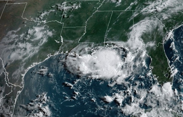
- (National Weather Service Lake Charles)
A tropical disturbance “meandering and moseying” toward the northeast Gulf of Mexico is expected to bring up to 6 inches of rainfall across Southwest Louisiana over the next few days. A few areas may see double those numbers.
“Rainfall forecast totals have come down a bit because this system hasn’t really gotten its act together at all in any meaningful way,” National Weather Service Lake Charles meteorologist Donald Jones said.
Computer models show the disturbance predominately hugging the coastline over the next few days, he said.
Trending
“As long as it stays along the coastline, it won’t be much to worry about except for the rainfall it will bring,” Jones said. “It would have to get a few miles off of the shore to develop any further.”
Regardless of development, heavy rainfall and flash flooding are the main concern. He said the slow-moving system is expected to bring rainfall through Saturday evening before dissipating over the area.
“Roughly about three days of rainfall could cause significant flash flooding across the region,” he said. “I don’t see much in this storm’s development future beyond heavy rainfall totals.”
At this time, chances do not favor wind or storm surge impacts to Southwest Louisiana.
“We’re also not expecting much of a tornado threat because of how weak and sloppy this disturbance is.”
He said upper-level winds are going to cause the storm to turn as it moves across the Gulf and that will be what causes the disturbance to dissipate in place. He said a low wind sheer is also working against the storm.
Trending
A flash flood watch will be in place 7 a.m. through 7 p.m. Thursday for central Louisiana with Oakdale and Jennings just outside of the watch zone.
Jones said “a reasonable worst-case scenario” would be the Lake Charles, Ragley, Jennings, Oakdale, Cameron and DeRidder areas receiving 4-6 inches of rainfall Thursday through Sunday. Leesville could experience 3-4 inches.
Chances favor heavy rain leading to rapid onset flooding. He said a flash flooding threat would be more likely Friday for Southwest Louisiana.
Rain should end Saturday evening in most areas.