WEATHER UPDATE: Tropical disturbance could bring excessive rainfall to SW La.
Published 2:42 pm Tuesday, July 15, 2025
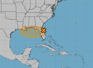
A tropical disturbance is expected to move into the Gulf of Mexico Wednesday morning.
National Weather Service Lake Charles meteorologist Donald Jones said there is a 40 percent chance this disturbance could intensify as it hovers in the warm waters of the Gulf.
Jones said a clockwise motion of winds behind the disturbance is steering the disturbance into the northern Gulf Coast. Sea surface temperatures “are plenty favorable,” he said, for the disturbance to develop further.
Trending
“The further south this storm gets, the more it will stay off land and off the coast and that will be favorable enough conditions for intensification to begin,” he said.
Strengthening into a hurricane is unlikely due to the limited amount of time the storm will have over the open waters, Jones said, as well as the presence of some disruptive wind shear.
“This is not expected to be a major system,” he said. “Even if it intensifies into a tropical depression or a tropical storm, it’s not expected to be very strong.”
Should the disturbance, though, become a named storm, it would be called “Dexter.”
Jones said computer models are currently predicting the system could make landfall in central Louisiana.
“There’s not necessarily an eyeball with this disturbance,” he said. “Where it makes landfall is not necessarily the issue; it’s the rain bands associated with it that is.”
Trending
He said “a reasonable worst-case scenario” would be the Lake Charles, Ragley, Jennings, Oakdale, Cameron areas receiving 6-8 inches of rainfall Thursday through Sunday. DeRidder and Leesville could experience 4-6 inches.
“Expect rain all day Thursday, all day Friday, all day Saturday, then it should get out of here,” Jones said. “That’s 72 hours of this very strong air mass.”
Jones said residents shouldn’t let their guards down just because this storm doesn’t have an official name.
“It’s going to be a fairly weak system, but that doesn’t mean it’s not going to be a threat,” Jones said. “Flooding is the largest killer of people during tropical systems.”
He said unnamed tropical disturbances are capable of producing tremendous amounts of rainfall that can cause dangerous and destructive flooding.
There is the potential the disturbance could stall over Louisiana. If this occurs, much higher rainfall and more widespread flooding can occur — with some localized areas potentially seeing up to 15 inches of rain.
A flood watch will be in effect for parts of Louisiana from 7 a.m. Thursday through 7 p.m. Saturday.
Jones said any tornado risk the storm could bring would be late Thursday or early Friday.