Dangerous impacts expected after dark as Hurricane Francine slams Gulf Coast
Published 3:09 pm Wednesday, September 11, 2024
Special to the American Press
Flash flooding, destructive winds, life-threatening storm surge and the threat of spin-up tornadoes will impact coastal Louisiana as Hurricane Francine hits the Gulf Coast.
“We’re concerned about the risk of damaging wind gusts and extended power outages as the strongest winds from Francine track dangerously close to New Orleans and Baton Rouge,” said AccuWeather Chief Meteorologist Jon Porter. “The winds will be powerful enough to take down power lines and trees, especially since the ground is saturated from recent rainfall before Francine arrived.”
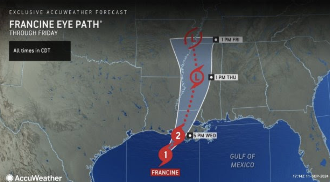
AccuWeather expert meteorologists are forecasting 6-10 feet of storm surge along parts of the Louisiana coast, with up to 15 feet of storm surge possible where Francine makes landfall. Storm surge is a rapid rise in water that inundates areas along the coastline and can be deadly.
The heaviest rainfall of 8-12 inches is expected in the area where Francine makes landfall in south-central Louisiana, with an AccuWeather Local StormMax of 24 inches. This intense rainfall can cause significant flash flooding that can lead to structural damage and road closures. River flooding is also possible going into the weekend.
AccuWeather expert meteorologists say there is also a risk of several tornadoes embedded in rain bands.
“Nocturnal tornadoes are extremely dangerous, especially when they are embedded in tropical rainbands. Tornadoes can be nearly impossible to see in the dark, especially if they’re wrapped in rain,” Porter warned. “Navigating through damage and debris in the dark is dangerous for storm survivors and first responders. It is critical for people to keep cell phones charged to receive potentially life-saving alerts from the AccuWeather app.”

Porter says people should stay indoors, away from windows, and avoid travel during the worst impacts of the storm.
Powerful wind gusts of 100-120 mph can occur near where the center of the storm moves onshore, with an AccuWeather Local StormMax™ of 130 mph. Hurricane-force winds can damage homes and businesses, sending dangerous debris flying through the air, which can compound the impacts and safety hazards.
“Batten down the hatches in Baton Rouge, get ready for up to six hours of powerful wind gusts and flooding rainfall,” warned AccuWeather Chief On-Air Meteorologist Bernie Rayno. “Conditions can be incredibly dangerous after dark.”
Heavy rain from Francine will continue to spread northward across Louisiana and the lower Mississippi Valley, extending into the central Mississippi and Ohio valleys throughout the rest of the week as Francine progresses northward. Rainfall totals of 1-2 inches are expected through much of the northern Gulf Coast and lower Ohio Valley. An area of 2-4 inches will extend through the panhandle of Florida, Alabama, Mississippi and southern Missouri.