UPDATE: Eye of Francine beginning to take shape
Published 5:12 pm Tuesday, September 10, 2024
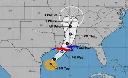
The eye of Tropical Storm Francine is beginning to take shape after dry air earlier in the day caused the storm to become somewhat disoriented.
National Weather Service Lake Charles Storm Warning Meteorologist Doug Cramer said Francine continues to head northeast with landfall predictions between Franklin and Morgan City.
Cramer said it was possible the storm could shift even further east toward New Orleans.
Trending
Southwest Louisiana could start experiencing tropical storm-force winds as early as 4 a.m. Wednesday. Lake Charles could experience winds in the 39-57 mph range.
A hurricane warning remains in effect for Cameron. When Francine does make landfall, the peak storm surge forecast is between 3-5 feet from the Sabine River to Rockefeller.
A flood watch remains for Cameron, Calcasieu and Allen parishes.