Central La. coastline expected to feel tropical storm-force winds Wednesday morning
Published 11:57 am Tuesday, September 10, 2024
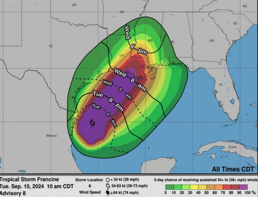
The Hurricane Weather Service had a more favorable weather report for parts of Southwest Louisiana Tuesday morning. National Weather Service Lake Charles Storm Warning Meteorologist Doug Cramer reported that dry air caused some disruption in the formation of an eye wall in Tropical Storm Francine, noting it’s still going to increase to hurricane strength but is now expected to hit the central Louisiana coastline tomorrow afternoon around Morgan City, likely as a Category 1.
The Monday afternoon NWS report — based on the most up to date information at that time — put landfall at the Vermillion and Cameron Parish line.
“As it approaches the coast, it will encounter a more shear environment which may put a cap on intensification,” he said. “That’s good news.”
Trending
Cramer said the central Louisiana coastline will begin to feel tropical storm-force winds Wednesday morning around 9, 10 or 11 a.m. Southwest Louisiana will have tropical storm weather conditions. The rain flooding threat has shifted more to the east. Since the eastern shift, Southwest Louisiana will have a lower likelihood of the tornadoes it saw during Hurricane Laura. The Lake Charles area will likely see an inch-and-a-half to three inches of rain.
Winds
The potential for winds range from 74 mph to 110 mph along the Southwest Louisiana coast over Vermillion, Cameron, Iberia and St. Mary parishes.
The potential for winds to range from 58 to 73 mph exists for areas east of a line from Lake Charles to Bunkie.
The potential for winds to range from 39 to 57 mph exists west of a line from Lake Charles to Bunkie.
“It will be pretty darn breezy in the Lake Arthur area,” Cramer said.
Trending
Rains
The potential for six to eight inches of rain exists across portions of lower Acadiana with isolated amounts up to 10 inches in lower Acadiana.
Some areas of southeast Texas and portions of central and western Louisiana may receive less than an inch.
Most locations across southwest Louisiana will receive between one and five inches.
Rainfall amounts along and west of Highway 165 have decreased due to an eastern shift in the forecast track of Francine.