WEATHER WATCH: Tropical development possible in southwest Gulf this week
Published 7:27 pm Saturday, September 7, 2024
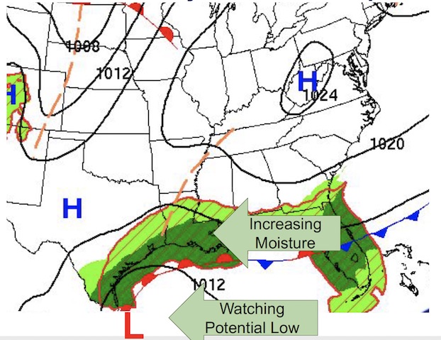
- Screenshot
Hurricane season will peak on Sept. 10 — and as that day nears, tropical activity could be approaching, too.
National Weather Service Lake Charles Meteorologist Donald Jones said an area of low pressure over the Bay of Campeche is moving slowly north across the western Gulf of Mexico. Should the disturbance develop over the next seven days, there will likely be some impact to the northern Gulf Coast.
“We’re giving it about a 70 percent chance of development,” Jones said. “This could be as low as a tropical depression or as high as a hurricane.”
Trending
As this system is in the early stages, there is still a lot of uncertainty, he said.
“Do not get fixated on one model runs as these can still change.”
A reconnaissance aircraft is schedule to investigate the system on Sunday afternoon.
Jones said sea surface temperatures at the moment range from 86 to 88 degrees across the Gulf of Mexico, which support tropical development.
Strong wind shear currently over the northern Gulf due to Friday night’s cold front is expected to remain in place through much of the upcoming week.
“Regardless of any kind of development, we’re going to see quite a bit of rainfall — especially Tuesday and Wednesday,” Jones said.
Trending
The combination of the potential tropical system in the Gulf and an old frontal boundary near the coast will increase the risk of heavy rainfall.
There is a 60-80 percent chance of seeing more than two inches of rainfall Tuesday-Thursday; there’s a 40-60 percent chance of seeing more than four inches.
“We’re looking at a very significant rain threat, whether this systems turns into a tropical system or not,” Jones said.