Update: Severe weather possible overnight, tomorrow
Published 2:41 pm Monday, January 2, 2023
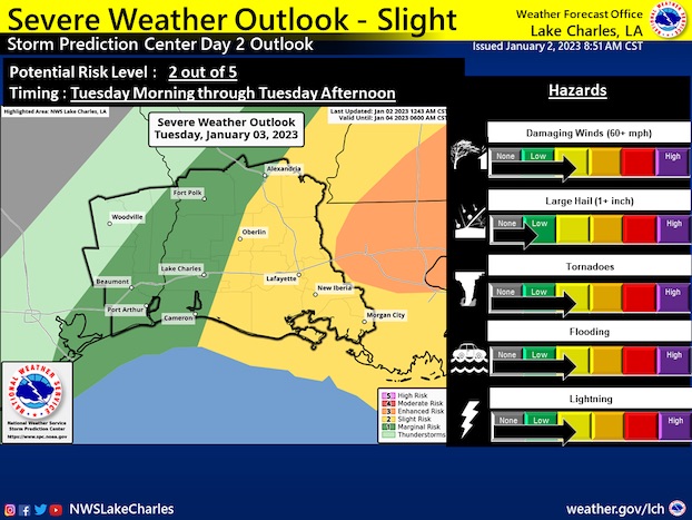
Heavy rain and severe weather are possible tonight and into Tuesday morning, with damaging winds and isolated tornadoes the main threats.
Donald Jones, a meteorologist with the National Weather Service’s Lake Charles office, said showers and thunderstorms capable of all modes of severe weather are expected overnight and will continue through much of Tuesday.
Heavy rain leading to flash flooding is possible, he said, as is large hail.
“The biggest overall threat, though, will be the damaging winds,” he said. “There is a 5-15 percent chance of us seeing winds of 60 mph or greater on Tuesday.”
Jones said Tuesday’s storms will start to become more organized and widespread by the early morning, with a squall line expected to develop along an approaching cold front.
“The ground is pretty well saturated from the weather we had a few days ago plus the moisture now dripping off the trees from the dense fog we’ve been experiencing,” Jones said. “There’s going to be the potential for very heavy rainfall, not necessarily for long durations, but a quick 2-3 inches in less than an hour and or two and when you are talking about receiving that amount that quickly the water doesn’t have enough time to runoff area roadways — that’s where the flash flood threat really exists.”
He said a warm front that made its way north into our area on New Year’s Eve is feeding off the moisture in the Gulf and when the cold front approaches from the west, that will cause the heavy showers.
“It’s not a very fast-moving storm so it won’t actually get here until Tuesday afternoon or late evening, but because it’s slow that’s why we’re looking at a couple of rounds of heavy rainfall,” Jones said.
He said the second-half of the week will be nice, with a nice breeze and sunny conditions.